
Embracing the Online Platform: Attract Users with Analytics
- iii
- Oct 19, 2017
- 3 min read

Let's take a trip down memory lane. Several weeks ago, we talked about the importance of interface when Embracing the Online Platform. If you remember, one consideration for the interface is to consider including more "advanced" tools. Then and there, we focused on seemingly simple features like hiding/showing overview maps and downloading datasets.
Today, let's explore this side, minus punctuated emphasis.
Incorporate analytics in your application or map whenever possible and/or relevant.
This seems a simple enough idea. If an application or map is built to allow for viewing data, of course you are going to want consumers to be able to analyze it...right? However, it isn't unheard of to get caught up in the process of producing the product that consideration for what power it will actually wield is left unaddressed. Being able to see data is beneficial, but it steps up the game when you can analyze that information as well...especially when not having to rely on outside resources.
Fortunately, features for analysis can be as involved as you or your client desired. These functions can be simple or advanced - or even both, if you want to set the bar high. Mix and match.
Simple Solutions to Study
The simpler side of your analytical prowess may include a number of features that you often use day in and out in other applications...so much so that they risk being overlooked. An example of this is the simple search. This functionality can be incorporated either by terms or location.
Search by Keyword
Shown below, Integrated Guardian presents the user with the option to search for terms within the map interface, navigating to results returned.

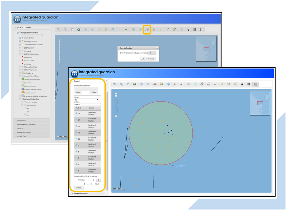
Search by Radius
On the hunt for assets that are in a specific location rather than match a certain attribute? A location-based search is what you need. In the example below, the user is able to deploy a radial search and return all assets that fall within those bounds.
Advanced Aspects of Analytics
The ability to search assets doesn't have enough horsepower for you or your users? More advanced options may include embedding actual geoprocessing tools inside the application itself. Virtually any geoprocessing operation, like Kriging or Inverse Weighted Distance (IDW) Surfaces, that can be published to ArcGIS for Server can be consumed and exposed by Map Control.

Features like this allow clients powerful geostatistical analysis capabilities that, previously, would have required access to programs like Esri's ArcMap or ArcGIS Pro in order to perform. More importantly, they would have to had to use ArcMap or ArcGIS Pro, forcing the option to export data. Why add an extra step or two to an already looming workflow when it is not necessary? We, for one, prefer making the workload of an end-user that much simpler.
About the Applications
Integrated Guardian | Code-name Environmental Effects Data Management System, Integrated Guardian allows easy access to large volumes of past and current data collected for EEM programs. It is designed to be accessible from a web browser and does not require the use of a plug-in.
Explore the Series
When building Web Applications and Web maps, there are key features and elements to take into consideration during the development and integration phases. Let us explore these features with examples of applications to illustrate their importance, such as...
Week 1 - Key Features of Apps and Web Maps
Week 2 - Importance of the Application's User Interface (UI)
Week 3 - Keep Primary and Supplemental Data at the Forefront
Week 4 - Attract Users with Analytics
Week 5 - Quick and Easy Reporting Prowess
Week 6 - Secure Content Management is Surprisingly Essential


Comments