
Product Launch: New LiDAR Toolkit Announced for Electric Utility Companies
- iii
- Mar 1, 2016
- 2 min read

New Toolkit Enables Electric Utility Companies to Improve Vegetation Management & Decision-Making Processes
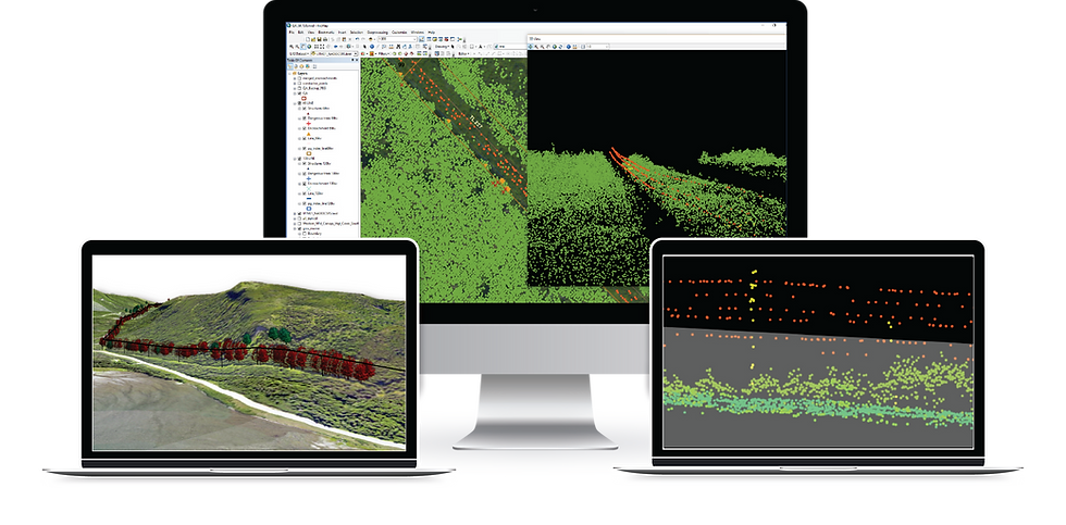
St. John’s, NL (Canada) – Integrated Informatics Inc. delivers a new set of tools to enable Electric Utility Companies using LiDAR, imagery, and Geographic Information System (GIS) technologies to better support vegetation management and decision-making processes. This toolkit provides a user-friendly, streamlined workflow to process LiDAR and imagery datasets, and includes the following functionalities:
Source Data Quality Assurance/Control
Vegetation Classification
Identification of encroaching vegetation and impeding foliage
Visualize encroachments along corridors using auto-generated profiles
Creation of 3D data (e.g., Digital Elevation Model, Hillshade)

Senior GIS Consultant for Integrated Informatics, Mark Kennedy, comments, “Electric utilities companies require vegetation management plans to remove and reduce the risk of vegetation encroachment along transmission right-of-ways. Traditional methods to identify areas requiring trimming and pruning are from visual inspections by ground or aerial surveys.”
The LiDAR Toolkit from Integrated Informatics generates an output of GIS data that can be used for further analysis and planning. In addition, a set of profile and plan views are generated to provide the user with alternative perspectives of sections along the right-of-way (RoW).
Kennedy, continues, “The LiDAR Toolkit provides an efficient and effective methodology for reducing the risks of vegetation along utilities corridors, saving time and providing accurate results. Users can now input various parameters, which allow rule adaptation, as determined by industry standards.”
Integrated Informatics Inc. is a leading consultancy for Geographic Information System (GIS) implementation and development. Founded in 2002, Integrated Informatics provides spatial data management, workflow and process automation, and custom mapping solutions to the Energy and Natural Resource sectors throughout North America with offices in Houston, Texas, Calgary, Alberta, and St. John's, Newfoundland. For more information, visit www.integrated-informatics.com.
Update (March 2017) - This application is now referred to as Integrated Forte. More information can be found by exploring Integrated's Solutions.


Comments