
Meet Integrated Forte: LiDAR Liaison for Utility Vegetation Program Management
- iii
- Apr 26, 2017
- 3 min read

If you have worked for or within the Utilities industry, you know one or two things about RoW management. For instance, you know that I am not actually talking about swinging oars across a lake.
RoW - or Right-of-Way - management is a large part of maintaining Utilities, whether they be Electric or Oil and Gas. Ensuring that the areas surrounding assets are routinely cleared and maintained helps to add longevity to your assets all while making sure crews are able to safely and quickly access them if need be. Improperly maintained RoW is a hazard that risks damage to materials and makes it more likely for outages to occur in the event of inclement weather. Take it from someone who has been on the receiving end of many a call during an Electric outtage, you do not want to be yelled at by a normally pleasant elderly lady whose episode of Wheel of Fortune was cut short. That should be on no one's bucket list.
Even though it is a hugely important part of the Utilities industry, there never seems to be quite enough for support in the software community for streamlining the processes involved with this side of the field. This may be because the Right-of-Way can be difficult and cumbersome to maintain, with approaches and needs differing by region as well as the areas in which assets lie. For example, the management of lines surrounded by a variety of vegetation have to be approached a little differently than those in less dense areas.
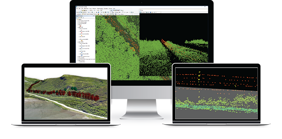
One asset in the modern Geographic Information System (GIS) world that has drastically helped to improve this - especially as it pertains to Vegetation Management - has been LiDAR. Because it allows for the classification of data based on type, it takes the "What is nearby?" question out of the equation within RoW management. Among the many regulatory programs in which these organizations must participate, Vegetation Management Programs (VMP) are the fastest growing. Those teams responsible for managing this aspect of the field need a quick and reliable way to determine the areas on which to focus the most attention. They also need a way to ensure the results of this analysis may be easily reported and understood by their colleagues and constituents. Not everyone can speak LiDAR, after all.
Harnessing the power of this data, we have designed Integrated Forte to aid in this process and provide solutions for companies to both run and maintain their VMP - all while adhering to those regulations administered by the NERC and other bodies.
Employed as an Add-In for ArcMap, it is highly customizable to account for these regulations and restrictions. The tools available within this solution allow for easily processing and analyzing LiDAR data to determine dangerous vegetation in the RoW, while also facilitating the recording of these areas to create reports and generate map books.
With Integrated Forte, you are one step closer to stepping back from forcing crews to wade around in a sea of brush wearing snake boots...or you know, interrupting the Wheel of Fortune broadcast for your customers. It is a win for crews and customers alike.

Integrated Forte is a prime application for Utility companies to confidently run and enforce Vegetation Management Programs (VMP) where dangerous vegetation along transmission lines and power lines must be identified and slated for maintenance. Learn more about this solution here.


Comments